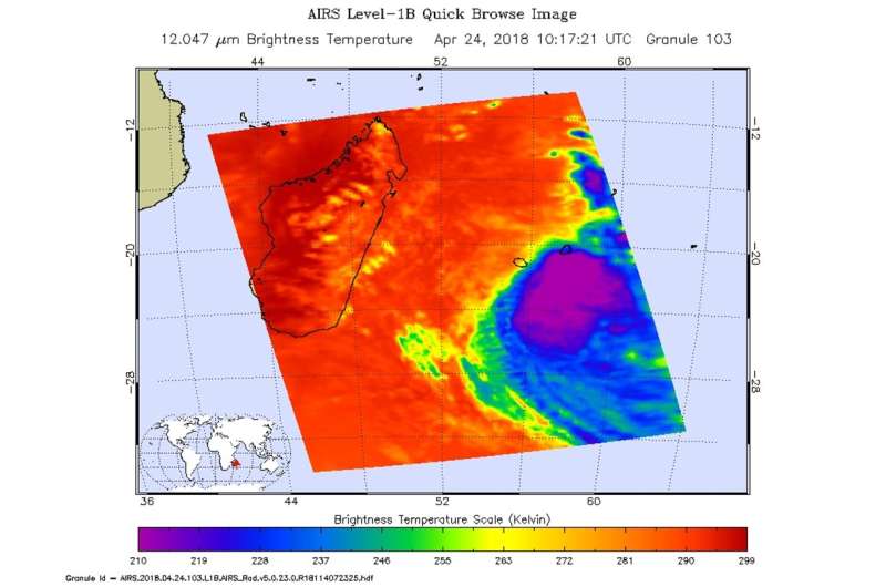
NASA finds Tropical Cyclone Fakir weakening

Infrared imagery from NASA's Aqua satellite revealed that Tropical Cyclone Fakir was getting weaker as it moved through the Southern Indian Ocean. The Joint Typhoon Warning Center issued their final bulletin on the system.
NASA's Aqua satellite passed over Fakir on April 24 at 6:17 a.m. EDT (1017 UTC) and analyzed the storm in infrared light. Infrared light provides temperature data and that's important when trying to understand how strong storms can be. The higher the cloud tops, the colder and the stronger they are.
AIRS data showed coldest cloud top temperatures in thunderstorms flaring around Fakir's center were warming, indicating weakening. Coldest temperatures were as cold as minus 63 degrees Fahrenheit (minus 53 degrees Celsius). Storms with cloud top temperatures that cold have the capability to produce heavy rainfall.
On April 25 at 11 a.m. EDT (1500 UTC) Fakir's maximum sustained winds weakened to 35 knots (40 mph/62 kph). The center of the tropical storm was located near 24.6 degrees south latitude and 59.1 degrees east longitude, that's about 288 nautical miles south-southeast of Port Louis, Mauritius.
The Joint Typhoon Warning Center said Fakir was moving southeast and is dissipating.
Provided by NASA's Goddard Space Flight Center


