Lightning flashes illuminate storm behavior

Anybody who has ever tried to photograph lightning knows that it takes patience and special camera equipment. Now, a new study is using those brief but brilliant flashes to illuminate cloud structures and shed light on storm cell behavior, giving weather forecasters new tools for predicting lightning hazards.
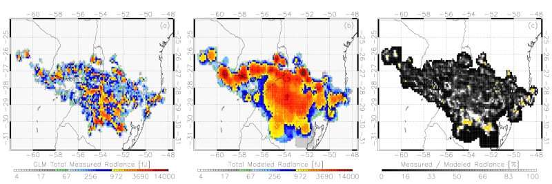
The new technique is "essentially lightning-based tomography, similar to a medical X-ray," said Michael Peterson, an atmospheric physicist at Los Alamos National Labs in New Mexico and author of the new study, published in AGU's Journal of Geophysical Research: Atmospheres.
"Using lightning flashes as the light source, we can identify contrasts in cloud layers that are indicative of dense regions, such as ones that might be laden with hail," he said.
Peterson drew upon data gathered by the Geostationary Lightning Mapper (GLM) on NOAA's GOES satellites. The GLM was designed to measure total lightning activity and provide that data to forecasters in real-time, but the products used in operations are only a small portion of GLM's capabilities.
"I think we're past the days of only using flash rates to characterize the lightning hazard," Peterson said. "We can learn a lot by examining how the flashes evolve and by observing how their optical emissions interact with the clouds."
Other teams have studied reflections and scattering in thunderclouds, but they tend to rely on computer models of simulated clouds that have simplified cloud shapes such as cylinders or horizontal planes.
"In the real world, storms are a lot more complex. We can learn a lot more about storm behavior by working with actual data observations gathered from actual storms," Peterson said.
This deeper dive into the GLM data can also help identify storm systems that may produce especially dangerous lightning, like horizontal flashes that can seem to strike out of the blue, Peterson said.
"When lighting strikes sideways, it can strike the ground well after the storm has already passed, when it may seem safe to go back outside," he said. These long horizontal flashes stand out clearly in the new imagery product, improving situational awareness, he added.
The next step will be to combine the GLM's optical imagery with radio-frequency measurements to construct a more three-dimensional view of the lightning and storm clouds.
"Right now, you can't tell for certain if you're seeing a cloud-to-ground flash or an intercloud flash with the optical data," Peterson said. "Radio-frequency measurements can provide altitude information, and that will allow us to make more accurate assessments about where the optical lightning emissions are coming from and how they're being transmitted through the clouds."
More information: Michael Peterson. Using Lightning Flashes to Image Thunderclouds, Journal of Geophysical Research: Atmospheres (2019). DOI: 10.1029/2019JD031055
Journal information: Journal of Geophysical Research - Atmospheres
Provided by American Geophysical Union
This story is republished courtesy of AGU Blogs (http://blogs.agu.org), a community of Earth and space science blogs, hosted by the American Geophysical Union. Read the original story here.


